|
Parallel to Merritt Avenue, it connects Post Rd. and Bogert Avenue. Also built in 1892, it may have been accepted as a public road in 1912. The source of the name is unknown, although it could have been in honor of Reverend John Walton, who donated his land on North Broadway for the first Presbyterian church in White Plains, where the current church stands.
0 Comments
Part of the White Plains Park development, it was laid out in 1892 and named for a local family. It is a dead-end road that runs northwest off Post Road right near the border with Scarsdale.
This road started out as a one-block road called Maple Street between Grant and Lenox Avenues when built circa 1893. It was renamed Morningside in 1903, perhaps to avoid confusion with Maple Avenue. The name may have been chosen in honor of the New York City road of the same name (see Lenox and Mt. Morris Avenues). An additional block north to Clinton Street was added in 1958 when the Cross-Westchester was built through Clinton Street.
Named for the tree, it connects N. Kensico with Mt. Morris Avenue near its southern end. It was built sometime circa 1893. 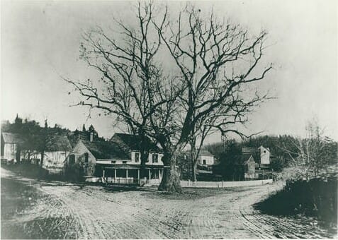 The Charter Oak, which once marked the border between White Plains and North Castle on North Broadway. It has nothing to do with Oak Avenue. Built circa 1893, it goes south from Grant Avenue and takes a strange curve onto Oak Avenue and then back to its original course. Part of a development known as Broadway Park, built by the Mt. Morris Real Estate Assoc., who named it after a street in Harlem, NYC (now called Mt. Morris Park West). Its namesake was a Tammany mayor of New York, Robert Morris (1841-44).
It was considered to be part of Lenox Avenue when it was built circa 1892. Henry Place got its current name in 1938, reason unknown. It connects N. Kensico and Beech St.
South of and parallel to Grant Avenue, it originally went as far east as Beech Street (but see Henry Place) and now ends just east of Crane Avenue's northern extension, the Cross-Westchester Expressway having cut it off. It was part of a development known as Broadway Park, planned by a group of people belonging to the Calvary Methodist Church of Harlem, who named it after a street there. It was seemingly accepted as a public road in 1905.
It was built east from N. Broadway by 1892 parallel to Clinton Street, but bridges carry it over the expressway and the parkway. The road was named for President U.S. Grant. It was accepted as a public road in 1919.
Built on the Fisher estate by 1891, it goes uphill from Post Rd. to Fisher Avenue, reaching the high land it is named for. The top block was accepted as a public street in 1895 and the rest in 1906.
Built in the Fisher estate by 1892, it was accepted as a public street in 1906. The source of the name is unknown.
Built by 1891 and made a public street in 1906, it is a dead-end road running southwest off Highland Ave. The source of the name is unknown.
Built apparently by 1886, it stretches between Odell Ave. and S. Lexington Ave. The original developer of this area was Caroline Fogg, and she named this road in honor of her husband and son, both named Charles.
These three roads which parallel each other originally connected Fisher Avenue and Westmoreland Ave., although Home has been a dead end before Fisher at Kittrell Park since 1975. All were built by 1881. Irving was originally known as Hillside Street and is one-way from Westmoreland to Fisher. The source of the names is unknown.
Parallel to Fisher Avenue between Tibbits Ave. and Bank St., it was built by 1881. The source of the name is unknown. It was connected to Bank Street until the urban renewal of the 198th decade.
James Ferris was the son-in-law of Jacob Purdy, Jr., and inherited his house in 1866. He built what was originally called West Madison Avenue circa 1885 (although it was east of the other two Madison Avenues in White Plains). At that time it ran from Ridge Street in the south (about where Hillside Terrace is now) to where Richards Street is now. It was donated by Ferris to the village of White Plains in 1894. In 1903 it was renamed to honor him. By 1930 there was another section going south from Cemetery Road, and the two were connected by 1938. The road was extended south to Hamilton Avenue opposite Bank Street during the urban renewal of the 198th decade. Another prominent Ferris in White Plains history was Elisha P. Ferris, who served several terms as village president.
When this road, which is north off Park Avenue, was built circa 1883, it was known as Highland Avenue. In 1903 it got its current name, and it was accepted by the village in 1915.
It stretches west from N. Broadway to Ferris Avenue. It was started circa 1883 and ended at the west side of Park Circle. The portion west of Park Circle was called Summit Avenue when built circa 1905. That part of the road was renamed in 1929. The original section was accepted as a public road in 1906. The basis for the name is unknown.
Built by 1881, it is named for the hill it is on, near Fisher Hill.
Existed by 1887, the reason for the name is unknown. It goes roughly southeast from Fairfield St. up to Chestnut Hill Ave.
This road apparently existed by 1879, running between Orawaupum and Bank Streets, with Crescent St. running uphill off it. The source of the name is unknown.
It appears on an 1881 map as Park Avenue, connecting Clinton St. to Orchard St. On an 1893 map, besides that portion, it also had a section running north off Henry Place to Grant Ave. They were connected apparently when Thompson Avenue was built, and at that time it was subsumed by Thompson. That situation changed when the Central Westchester Pkwy. was built, and Beech Street regained its earlier name in 1938. On the official city map, there is another section which is south of Henry Pl.; that is just a paper street. The name comes from the tree. (Post corrected)
Going by other names early in its existence, such as Sone Road (for a local family which owned much land in this area) and Garden Road, which is its name in Scarsdale, this road was begun before 1881. Then it went from Old Mamaroneck Rd. to Soundview Ave. By 1900, it seems to have been extended into Scarsdale. Now it is named for our neighbor, a hamlet in Greenburgh.
Seemingly named due to the cottages built along it in its early days, this road went between Hamilton Avenue and Barker Avenue when built circa 1878. By 1899 it had been extended north to what is now Rockledge Avenue. Its original block was accepted as public in 1891, and, perhaps inadvertently, renamed Cottage Street.
Built by the village of White Plains in 1875, this street runs down from Washington Avenue to Tarrytown Rd., and naturally enough got its name because there was a school (Chatterton Hill school) at its head on Washington.
|
AuthorMy name is Cliff Blau. I was born and raised in White Plains, NY, and in 2015 became interested in learning more about the history of this fair city. The pathway I took into White Plains history was to discover the reason for the names of each of the streets. See https://www.google.com/maps/d/viewer?mid=1WvlOinVQnWh4KGDmEN7YPFfg4II for an annotated map of White Plains. Archives
March 2024
Categories |
 RSS Feed
