|
During construction of the Cross-Westchester Expressway in 1958, the intersection of Orchard Street and N. Broadway was moved a bit to the north. In 1966, in order to straighten out Orchard Street, a new section was constructed to the east of that, and this short road, which was part of the original Orchard St., was renamed Orchard Place. It stretches from Hawthorne St. past Montross St., at which point it becomes an entrance ramp to the Central Westchester Pkwy.
0 Comments
Dating to 1735, this road which goes east from N. Broadway before curving northeast up to Reservoir #2 was originally known as Fisher Lane. It was given its current name circa 1869 by the Village Board of Trustees. I don't know if fruit trees were grown here.
This road started as part of West Street. The Gedney family farm was in this area, from which it eventually got its current name after Mamaroneck Avenue was built circa 1872. Gedney Way stopped at Old Mamaroneck Rd. originally. It was extended to connect to Prescott Avenue circa 1924.
Another of the first roads in the town of White Plains, it was known as the Road to Rye Neck in the early days, since that is where it terminated. Now (since 1986) it is cut off by the Hutchinson River Parkway and bends into Purdy Avenue, although the southern section still goes through Harrison to Harrison Avenue. Before Mamaroneck Avenue was built, West Street occupied a part of its route before heading west as what is now Gedney Way. Now it terminates at Mamaroneck Avenue south of Carrigan Avenue. Laid out in 1725, a part of it near Rosedale Avenue was deeded to the city in 1957. As for the name, it may have been picked because it was west of North Street, the other main north-south road in the area back then (although shouldn't North Street have been named East Street?)
When built circa 1725, it was known as the Road to Mamaroneck Town, since all road names were descriptive then. It was also known informally as Horton Avenue after a local family who owned land along the road, including what is now the Carhart neighborhood. When Mamaroneck Avenue was built in the early 1870s, it took over the northern part of this road, from where Old Mamaroneck ends now to what is now Main Street.
Dating to at least 1721, and rerouted by 1762, it had several earlier names before going by Cottage Avenue in the latter half of the 19th century. A man named Aaron Hall bought substantial land in the area and the street was officially renamed for him in 1903. Until 2009 it connected Lake St. with Buckout Rd. in Harrison, but the bridge from Lake St. was removed due to renovations to the Cross-Westchester Expressway. Part of the city border is along this street.
The earliest homes in White Plains were built along North Street, roughly where Westchester Avenue is now, and the town soon started moving up the hill towards Main Street. What is now North and South Broadway was laid out by 1697, but wasn't formally dedicated until 1734, when it was officially called The White Plains Street, but commonly referred to as the Village Street. It ran from the northern border with North Castle to what is now Maple Avenue. It was extended from Maple to Livingston Avenue by 1906, when that portion was made a public road, and later to Mamaroneck Avenue by 1908. The dividing line between North and South is Main Street. Its name comes from the fact that it is wide, with the name Broadway first appearing in records in 1850.
In the early years, what is now Tibbits Park was known as the commons, and farm animals would graze there unsupervised, much to the disgust of everyone who didn't own those animals. Year after year they would ban animals from wandering around loose on the commons, with the exception of pigs with rings through their noses to keep them from digging up roots. Hence, they wrote that “swine may be commoners if they are well-rung”. Prior to 1937, this road running one block between Post Road and Stevens St. was considered to be part of Colden Avenue, but since there is a several block gap between them, this portion was renamed in honor of former President Millard Fillmore.
Part of the White Plains Park subdivision, this road was named in honor of Cadwalder Colden, who performed the survey for the 1721 royal patent. It connects Greenacres Ave. and Walworth Ave. and was laid out in 1892. Part of it was accepted as public in 1907.
Soon after the purchase of Quarropas, the settlers from Rye were confronted with the claim of John Richbell of Mamaroneck, who said that he had purchased the area in 1660. The dispute was not resolved until 1721, when the Rye settlers received a royal patent from King George I.
All printed sources claim that Richbell Road is named after John Richbell, but I have my doubts. Besides the fact that he is more or less a villain in the White Plains story, there is the fact that no other streets in the Gedney Farm Gardens area are named after similar historical figures. Rather, I believe the street was named after the Rich family, whose mansion still exists on Ridgeway, near the northern terminus of Richbell Road. See Ethelridge Road for more. Richbell Road was built in several stages, starting around 1926, going south from Ridgeway to a bit south of Ethelridge. It came to a dead end just south of Lambert Road from the mid-1950s until the 1983, when Barton Road was built through and Richbell was connected to Morgan Place. The portion from Ridgeway to south of Ethelridge was accepted as a public street in 1931. In 1967 the section from there to south of Lambert was deeded to the city. The last addition was deeded to the city in 1995. First laid out in 1717, it was earlier known variously as the York Road to Eastchester and the New York Post Road. Its eastern end was (then the end of) Broadway. In the mid-19th century, the Post Road was reworked to be straighter, and the original road, now ending at Lexington Ave., was known as the Old Post Road until 1891, when it acquired its current name. It doesn't seem to have been named after any specific maple tree. The section running west off of Bloomingdale Rd. was originally known as Greene Place. That road ran directly up to Lyon Place, but was rerouted to connect to Maple in 1954 and then lost its separate name. Maple was extended westward to Post Road in 1959.
When the Cross-Westchester Expressway was cut through North Kensico Avenue in 1958, this service road was constructed to re-establish a connection to Lake Street.
Named for one of the Indian sachems who sold Quarropas to the Rye settlers; his name was spelled three different ways on the deed. The road was only north of Lake Street when built circa 1870. The part now known as South Kensico, south of Lake Street, was originally called Hatfield Avenue (on 1893 map), after Gilbert Hatfield, who owned the high ground north of Lake Street during the Battle of White Plains. It ended just south of Oakley Avenue. Its name was changed by 1900. The final portion, going to Westchester Avenue, was built c. 1909.
These roads, near the Mamaroneck Avenue School, which were built circa 1909, were named after a couple of the Indian sachems who sold Quarropas to the Rye settlers. The development was called Wonawaking Park.
Built circa 2007, this road goes north from Lake Street into the Horton's Mill Condominium complex. This complex was built on what was the site of Horton's Mill in the 18th century and was later Charles Deuterman's ice house. 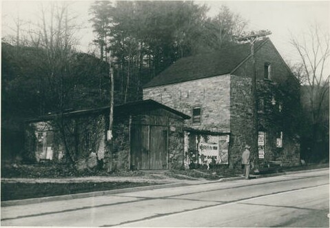 Horton's Mill First laid out in 1762, it was called Road to Kings Street or Road to Connecticut, becoming commonly known as Lake Street by 1870, although it appears as Harrison Street on an 1872 map. It is obviously named for Silver Lake, which was originally created by Benjamin Brundage in 1726, later becoming known as Horton's Pond, and other things. It took the name St. Mary's Lake in 1847, and had that name when the Lake Street name was adopted. Silver Lake came many years later. The Mamaroneck River flows out of Silver Lake and serves as a border for White Plains and Harrison. 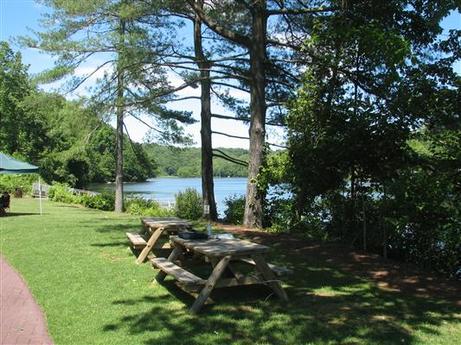 Silver Lake Named for the West Branch Brook, which is the western spur of the Mamaroneck River. The brook serves as part of the border between White Plains and Scarsdale. It was built circa 1953 and made a public road in 1955.
It was named for the Bronx River, which it runs alongside from the NY Botanical Gardens to the Kensico Dam Plaza. The Bronx River serves as part of the border between White Plains and Greenburgh, although not so extensively as it did originally. Completed in 1925, it was the first public parkway in the United States of America designed for cars. It was appropriate that it went through White Plains, since according to the 1930 census, White Plains had the highest rate of cars per capita in the country. The construction of the Bronx River Parkway required the elimination of certain streets, such as Greenburg Avenue (Mill Lane) and Smith Street on Chatterton Hill. 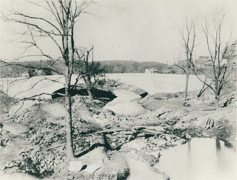 The Bronx River The area the Rye settlers purchased was known as Quarropas, which translates as White Marshes, or White Plains. White Plains was considered part of Rye until it became its own town in 1788, and interestingly was actually part of Connecticut at the time of its founding. This is due to a border dispute between New York and Connecticut, which was resolved six days after Quarropas was deeded to the English. Quarropas Street was built west from Mamaroneck Avenue by 1885 (possibly by 1881) and accepted as a public road and named in 1887. Its original western terminus was what is now Dr. Martin Luther King Jr. Boulevard. During urban renewal, circa 1980, it was extended to South Lexington Avenue. 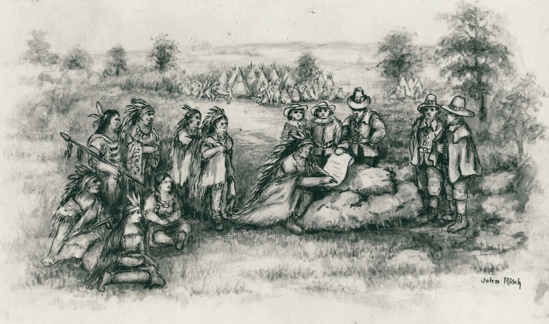 The purchase of Quarropas as drawn by former city historian John Rosch. On November 22, 1683, a group of English settlers from Rye came up an Indian path to meet with the local Weckquaskech Indians at the present day site of the Westchester mall. There they arranged the purchase of a territory of a bit more than 4400 acres (White Plains today consists of just under 6400 acres). The path they took became a street in 1708 known as the Road to Rye before officially becoming the Queen's Highway. By 1846 it had the name North Street, likely because it goes north from Rye. It originally went all the way to Broadway, but when Westchester Avenue was built circa 1870, the end was changed to where it merges into that road at White Plains Avenue northbound, and a bit west of that southbound. A small bit that had been stranded north of the new Westchester Avenue was eliminated circa 1885. 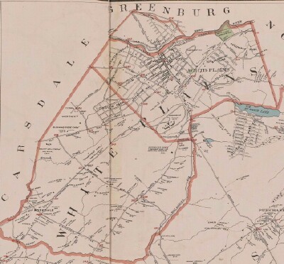 Town of White Plains, c. 1893 While looking at old maps of White Plains, I realized the extent of the changes that have taken place in this city, and are still taking place. I realized that I could tell a lot of the city's history by the history of the streets.
A lot of streets got their current names because, well, they had to have some name. There are plenty of streets named after general geographic features such as ridges, views, etc. Since most of the streets were privately developed and named, some speculation has been called for on my part as to the origin of the names. Sources- In researching this subject, I consulted a number of histories of White Plains and Westchester County. Of particular value were Renoda Hoffman's books It Happened in Old White Plains and Yesterday in Old White Plains, and Historic White Plains by John Rosch. Also quite helpful were various maps of Westchester and White Plains dating between 1858 and 1998 and a transcription of a speech by William A. Woodworth in 1905 entitled, “The Call of the Old Village Street”. Newspapers used include the Eastern State Journal, Westchester News, Reporter Dispatch, and the Journal News. Also, periodicals called the Real Estate Record, the Interstate Record, and the Building and Realty News, and many subdivision maps and deeds filed with the County Clerk's office. I consulted numerous White Plains city directories as well. Many thanks are owed to the helpful staff of the White Plains Public Library, especially local history librarian Ben Himmelfarb, and to City Archivist Elaine Massena and City Clerk Anne McPherson. Most photographs courtesy of the White Plains Library. |
AuthorMy name is Cliff Blau. I was born and raised in White Plains, NY, and in 2015 became interested in learning more about the history of this fair city. The pathway I took into White Plains history was to discover the reason for the names of each of the streets. See https://www.google.com/maps/d/viewer?mid=1WvlOinVQnWh4KGDmEN7YPFfg4II for an annotated map of White Plains. Archives
March 2024
Categories |
 RSS Feed
