JEFFERSON AVENUE, LINCOLN AVENUE, MCKINLEY AVENUE, FOURTH STREET, FIFTH STREET, and PRIMROSE STREET11/30/2016 It might seem odd to have a Fourth and Fifth Streets without a First, Second, or Third Street. The reason is that there were such streets originally, along with a Sixth Street, but the latter four had their names changed. The numbered streets were developed circa 1869, running south from Chatterton Avenue about 300 feet. Later, Jefferson was built (by 1910?) and connected to First Street, which was renamed to Jefferson in 1926, a year after Jefferson was made a public street. Second Street was renamed to Lincoln Avenue in 1930, the same year it became a public road. McKinley is the oddball among these presidentially-named streets since it was accepted as a public, unimproved road in 1916 and it was renamed to Third Street. The through road was renamed back to McKinley in 1925. Primrose was built circa 1895 as part of the Vivian Heights development, while the presidentially-named streets were part of the Washington Heights Park subdivision. It was connected to Sixth Street in 1913 and the latter was renamed to Primrose circa 1929. Fourth and Fifth Streets remain unaltered.
0 Comments
This road was named after two presidents, since it was known as Washington Avenue (one of three roads by that name on Chatterton Hill) when built circa 1870. It was renamed in honor of the recently deceased president in 1924. Harding Avenue connects Battle Avenue with Russell St.
Built circa 1870 and originally known as Bronx Avenue, it was renamed in 1903 in honor of William H. Robertson (1823-1898). Robertson served as U.S. Representative from Westchester, Rockland, and Putnam counties, as well as a state senator for 16 years and an assemblyman, two terms as supervisor of Bedford including one as Chairman of the Board of Supervisors, the first president of Westchester Bar Association, and twelve years as County Judge, among other offices. Most notably, he was chairman of the county Republican Party for some thirty years.
Myndert Fisher owned a big chunk of land prior to his death circa 1880. It was bounded on the east by Winchester St., on the north by Martine Ave. and the railroad, on the south by Post Rd., and on the west by Tibbits Ave. He laid out his road through his land circa 1870 from Winchester to Tibbits. It was extended eastward to what is now MLK Blvd. in 1930, but in the urban renewal era, starting 1978, its east terminus was changed to Lexington Ave., with a little stretch left over near MLK Blvd. See Fisher Court. The western side was extended to the village line in 1898 (but see Walworth Terrace). Fisher Avenue was accepted as a public road from Brookfield St. to Orawaupum Ave. in 1887, from Orawaupum to Tibbits in 1891, and the balance in the west in 1907.
Built circa 1869, Bank Street's southern end is at Fairfield Street and, due to reconstruction during the urban renewal project of the 198th decade, it is discontinuous at Fisher Avenue. Originally its northern end was at Traverse Street (which was a bit north of Westmoreland Ave.) and by 1893 it ended at Martine Avenue, but it was extended up to Main Street by the city while Orawaupum St. was shortened during urban renewal. The reason for the name is unknown. It was made a public road between Martine and Fisher in 1894 and from Fisher to Fairfield in 1909.
Stephen A. Martine owned the land south of Main St. and north of Post Rd. between Winchester St. and Mamaroneck Ave. in the mid-19th century. A road was built by the village through it from Lexington Ave. to Mamaroneck Ave. in 1869 and a few years later it was named for him. It was extended east to Broadway circa 1901 and west beyond Orawaupum St. by 1881 and in 1887 that portion was made public.
It began its existence as part of William Street, and in 1914 the portion from Rockledge Avenue north to Park Avenue was renamed as Hillside Avenue. The part south of Hillside Terrace was eliminated circa 1976 as part of the urban renewal plan. Its name is appropriate, as it is on the side of Purdy Hill.
Named for Charles H. Davis, who started this street on his property between what are now Post Rd. and Maple Ave. circa 1870 (his property stretched south of the village line). Note that Davis Brook and Davis Pond, both now buried, are also named for him. By 1900 it had been extended beyond Prospect St. and there was an unconnected section going north from Prescott Ave. to beyond Bryant Ave. which was built circa 1896. Then, by 1914, those two roads had been connected and went south of Prescott to a dead end near Hartsdale Ave. By around 1925 it had reached its current southern endpoint of Hartsdale Ave. The section from Prospect St. to Smith Avenue was accepted as a public road in 1915.
When built late in the 187th decade, it stretched west from N. Broadway to William Street. In 1901, it was connected to Spring Street, but in the urban renewal phase of the 197th and 198th decades, it was shortened just a bit to end at what is now MLK Blvd. It was accepted as a public road from William to just before the Presbyterian Church in 1894 and to Broadway in 1897. Also known as Barker Terrace for a while in the 19th century, it was named for William Barker, who was the first postmaster of White Plains and co-founded the first medical society in the state of New York in 1797. His house was in this area, originally on Broadway and later on Rockledge.
This is really nothing more than a driveway north of Main St. now, but when originally laid out circa 1868, it ran all the way from Main to what is now Hillside Avenue until it connected to Park Ave. It was discontinued during the urban renewal period from 1968 to 1976. The name comes from William Smith Brown, who built it and whose heirs still owned part of the road until the city claimed it in 1968.
Dating to the late 1860s, it originally ended in the east at Spring Street somewhat north of Barker Avenue and in the west just past N. Lexington Avenue. After 1930 and by 1938 it had been extended west to Mott St., where Ferris Avenue is now. In the urban renewal period of the 197th and 198th decades, Spring Street was eliminated and Water Street was extended east to what is now MLK Blvd., where it meets Barker Avenue. The name likely comes from the fact that Davis Brook runs just to the north of the road. It was made a public road in 1894.
Dating to 1868 if not earlier, this road near and named for the Bronx River has been reworked several times. It was once a major road which connected to the area west of the river via roads which no longer exist, but is now basically a service road which is one way from Hamilton Ave. to Main St. and runs along the west side of the train tracks north of Hamilton. In the 188th decade, it was often referred to as Frog Alley due to its condition after the Bronx River would flood. It was accepted as a public road in 1888.
It starts off east from S. Lexington Ave. and then turns sharply south-southeast to Prospect St. The road from circa 1870 is named for Cambridge, Massachusetts, where Charles Fogg, husband of developer Caroline Fogg, was born.
This road doesn't live up to its name, since it doesn't cross any street. It goes northwest off Central Avenue near Chatterton Ave., and forks into two roads in Hartsdale. Cross Street was built circa 1870.
This brief, two block road running from Russell St. to Central Ave. was called Madison Avenue when built circa 1870, and like the other two Madison Avenues in White Plains, it was renamed. This one took the name of the recent USA President Woody Wilson in 1922.
These streets are named for Michael Chatterton, whose house was at the base of what is now known as Chatterton Hill (aka Battle Hill), where much of the Battle of White Plains took place in November 1776. Interestingly, Chatterton Hill was not part of White Plains at the time, since the Bronx River was the dividing line between White Plains and Greenburgh. A White Plains Fire District was created by the state legislature in 1858 which encompassed roughly the northern half of the town of White Plains. In 1862, it was expanded to embrace part of the town of Greenburgh, including Chatterton Hill. Four years later, on May 1, 1866, the village of White Plains was incorporated (after an 1861 attempt failed to pass the state legislature), and its boundaries were the same as those of the Fire District. The incorporation was pushed by the Democratic Party, and its boundaries seem to have been politically motivated. Most of the Republicans in White Plains lived in the southern half of the town, which remained unincorporated, and at least 90% of the voters in the Greenburgh part of the village were Democrats. Chatterton Parkway was laid out in 1894 and had been named by 1898, although it wasn't completed until the 20th century, and it became a public road in 1917. Chatterton Avenue was on an 1867 map. 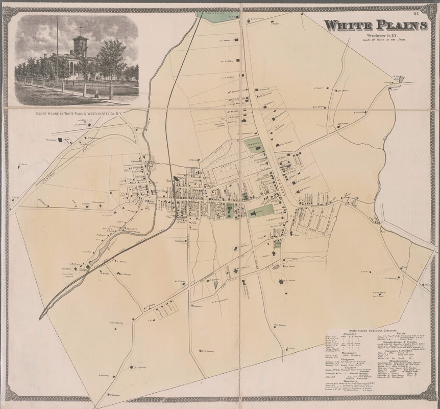 Still another of the major roads constructed through the county after the Civil War, it stretches from Mamaroneck Harbor up to Main Street in White Plains. The northern end of it was originally known, unofficially, as Horton Avenue, which was part of the original road to Mamaroneck now known as Old Mamaroneck Road. Another large section of it was previously part of West St., which once ran into Old Mamaroneck Rd. via what is now Gedney Way. The only new parts in White Plains were the section south of where West St. now intersects with Mamaroneck Avenue and the stretch north of Gedney Way to the intersection with Old Mamaroneck Rd.
Another of the Westchester roads built beginning late in the 187th decade, it was originally supposed to run from Central Park in New York City (hence the name it goes by south of White Plains) all the way to Boston Post Road in Port Chester. That plan was opposed by the Republican Party, and when Judge Robertson convinced New York City to annex the southern part of Westchester, now the Bronx, which was heavily Democratic, the Republicans gained control of the Westchester Board of Supervisors and were able to kill the project. When terminated circa 1870, it went from the Bronx to the bridge over the Bronx River on what is now Main St. in White Plains. There was still talk of essentially completing the route in the mid-20th century.
A few years after the Civil War ended, New York State funded a program of road building in Westchester County and this was one of the products of that period. Named for the county, it was begun in 1868 and finished circa 1872. Traveling from near the Byram River in Port Chester (originally known as Saw Pit), it occupies a part of the original route of North Street leading to Broadway in White Plains.
Begun circa 1865 in conjunction with the building of the Grace Episcopal Church, for which it is named, it was originally only two blocks long, from what is now Main Street to Barker Avenue. By 1887 it had been extended to what is now Rockledge Avenue and to Park Avenue circa 1894. It went a little further north by 1914 and to about parallel to the northern end of Park Circle by 1930. Also, the northern end south from Westview Avenue had been started by 1929. They were connected within a few years. The southernmost block was accepted as a public road in 1885 and the block from Hamilton to Barker in 1888. The public portion was extended to Rockledge in 1897.
Until late in the 19th century, all White Plains streets were dirt roads. Railroad Avenue was the first to be paved, or macadamized, as it was then called. Winchester was “a street more in name than in fact” until Davis Brook, which ran down the middle of the road, was buried in 1900. Its history as well as its path parallels that of Brookfield Street, except that Winchester was shorter. Once going from Martine Ave. to Post Road, its southern block was shut down for the building of Winbrook in 1950, and the balance of the road was discontinued between 1970 and 1973, leaving just a stub north of Post Road today. The source of the name is unknown
Now a dead end stretching a few feet north from Post Road, it once ran between Post and Main St. It started circa 1844 as a road called Rabbit Street, after local resident Dennis Rabbit, which like Court, Grand, and the former Grove, went south a few hundred feet from what is now Main St. The rest of the road, with a name derived from its proximity to a brook, was built between Martine and Post by 1881 and was accepted as a public road in 1887, although the original portion wasn't made public until 1895. When the Winbrook housing project, which got its name from this and Winchester St., was being built in 1950, the block between Post and Fisher Ave. was discontinued. The northern portion was eliminated between 1969 and 1973 as part of the urban renewal of that era.
Whoever named this street when it was commenced circa 1856 was overly optimistic, since it has never been particularly grand. Like MLK, which it paralleled, it at first just ran a block or so south from what is now Main St. When photographer William Maynard bought the Martine property, he divided it into lots and extended Grand Street to Post Rd. circa 1886. The stretch between Martine Avenue and Quarropas St. was made public in 1887 and the portion from Quarropas to Post Rd. was made public in 1891. The two blocks north of Quarropas were eliminated during the urban renewal period 1970-1977. At one time, the main post office was on Grand Street.
The street with the longest name and the first in the city with its namesake's full name, it was called Grove Street when it was started circa 1856, stretching a bit south from what is now Main St. to where Martine Ave. would be built. By 1880 it had been connected to Post Rd. and by 1912 it was further extended to Maple Ave., although that last block is now considered to be Longview Ave. The second section was made a public road in 1887. Grove Street was extended north to Barker Avenue and Water Street in 1969. It was renamed in honor of the civil rights leader in 1997 after the Common Council considered giving that name to other streets including Fisher Court and Lexington Avenue.  Circa 1910, when it was called Grove Street. This road existed by 1867, and was apparently at one time called the Old Road. It was formally known as North Street until July 1929, when it was renamed Mason Street, but the residents didn't like that name, and later in the year it was renamed Russell Street, in honor of John C. Russell who owned a farm here in the mid-19th century. It goes west off Central Avenue across Fulton Street and into Greenburgh.
|
AuthorMy name is Cliff Blau. I was born and raised in White Plains, NY, and in 2015 became interested in learning more about the history of this fair city. The pathway I took into White Plains history was to discover the reason for the names of each of the streets. See https://www.google.com/maps/d/viewer?mid=1WvlOinVQnWh4KGDmEN7YPFfg4II for an annotated map of White Plains. Archives
March 2024
Categories |
 RSS Feed
