|
Running roughly west from Old Mamaroneck Rd. near Gedney Way, which merges into it, Prescott Avenue goes to Soundview Ave. It was built circa 1896 through both Grandview and Soundview Heights. The source of the name is unknown, although it was possibly named for the commander of the colonial troops at the Battle of Bunker Hill, William Prescott.
0 Comments
Begun as part of Grandview Park, it was built from Bryant Avenue to Prescott Avenue circa 1896, and extended south of Locust circa 1923, and to Hartsdale Ave. in or about 1925. Furthermore, the road now called Leith Place was originally part of Ogden Ave. It was apparently named for David Ogden, one of the earliest settlers of White Plains, who lived in the Highlands area.
The namesake of Grandview Park, this road has much the same history as those it parallels, such as Greenridge and Longview. However, it was never built north of its original Linda Avenue terminus. The part north of Bryant Avenue was made public prior to 1925.
This road was begun circa 1896 as a part of Grandview Park. It ran from Longview Ave. east towards Old Mamaroneck Rd., which it was connected to by 1900. By 1914, it had been extended west by John Miles and curved southwest until it met Bryant Ave. The source of the name is unknown.
This road was built circa 1896 as part of Grandview Park. It goes roughly south off Byron Ave. to a dead end just south of Stratford Ave. (which ends east of Herbert Ave.) The reason for the name is unknown.
Going south from Maple Ave. to a dead end after Charles St., this road was called Washington Street when built in the mid-1890s, because you can't have enough streets named after George Washington. It was renamed to Roosevelt Avenue in 1903, after the then-current U.S.A. President, Theodore Roosevelt. However, it is identified as Roosevelt Street on road signs and on the city map.
At first called Grant Avenue when built in 1895-6, it was renamed in 1903, apparently after John and Samuel Odell, a couple of the earliest settlers of White Plains. It was made a public street in 1908. Odell Avenue traverses the land between Osborne St. and Maple Ave.
Built circa 1895, it runs from Chatterton Pkwy., where it connects to Chase Ave., north to Central Avenue. The source of the name is unknown. It was originally a dead-end south of Concord Avenue but was extended to Chatterton Pkwy. circa 1945.
Named for then-President Grover Cleveland, it was built circa 1895, stretching from Trenton Avenue to near Central Avenue. In 1913, it was extended to intersect with Central Avenue.
A short dead-end street that goes west from Waldo Avenue, the source of the name is unknown. It was built circa 1895 as part of the Vivian Heights development.
David Cromwell, a distant relative of Oliver Cromwell of English Civil War fame, was a prominent citizen who served as county treasurer and president of the village of White Plains, among other positions in government and civic organizations. He was also president of several banks in White Plains including the Home Savings Bank. His first home in White Plains was at what is now 7 Cromwell Place and is known as the Percy Grainger House, after the famous composer who later lived there. Cromwell built these two streets which connect Maple Avenue and East Post Road. Chester Avenue, built and deeded to White Plains in 1891, was named for his son John Chester Cromwell, who was just shy of 13 years old at that time. Chester later lived in a house on the road named for him, which still stands behind the Percy Grainger House. He died in 1907 fighting a fire on Main Street. Cromwell Place was laid out and deeded to the village as a public road in 1893. 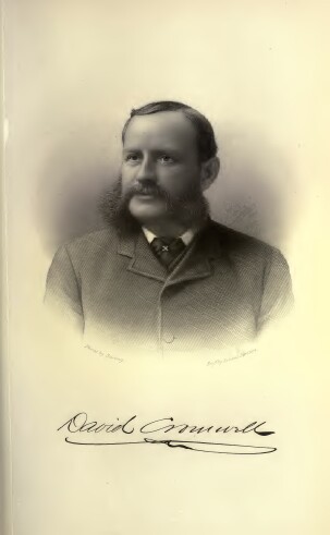 This road has a complicated history. In 1893, it stretched from S. Lexington Ave. east to Old Mamaroneck Rd. By 1901, it had been expanded west to Soundview Ave. on what is now Byron Ave. and by 1908 east to near Mamaroneck Ave. in Wonawaking Park, and to Mamaroneck Ave. by 1914. It continued eastward as far as Hathaway Lane (which then went to North St.) in 1928 and Colonial Road (taking over what had been Hathaway Lane) in 1934. The final stretch, to Westchester Ave., was completed in 1968. In 1932, the portion west of S. Lexington was renamed to Byron (and Bryant was slightly redirected). In addition, the source of the name is not clear. The Reporter Dispatch claimed it was named for either newspaper editor William Cullen Bryant or a local businessman named William A. Bryant.
When it was first laid out circa 1893, it went from Old Mamaroneck Rd. in the east to just past S. Lexington Avenue in the west. In 1927 it was extended slightly west to Ralph Ave. A few years earlier, it had been built east to Mamaroneck Ave. The source of the name is unknown.
It was known as Stirling (or Sterling) Avenue when started circa 1893. At that time it spanned from Old Mamaroneck Rd. to Ralph Ave. It was extended east to Overlook Rd. circa 1923. In 1932 it was renamed to avoid confusion with the other Sterling Ave. Why the name Stratford was chosen is unknown.
This road was begun circa 1893 as part of a development known as Longview Park. In 1896 the development changed hands, perhaps as a result of the depression which began in 1893, and became Grandview. Longview originally stretched north from Prescott Avenue to about the present location of Linda Ave. In 1897 an additional section was laid out from Maple Ave. south to connect with the original road. Another block, between Maple Ave. and Post Rd. was built circa 1906, connecting to what is now Dr. Martin Luther King, Jr. Blvd. The last bit, going south of Prescott to Thomas Pl. was added circa 1923. The name seems to refer to the availability of a good view from this area.
When built together with Franklin Ave. by William L. Banks circa 1894, it went from Lake Street south to Franklin. Its southern block was eliminated in 1967 so it now ends at Main St. The street became public in 1903. Its name (originally East View Avenue) seems to come because there is a nice view to the east from there.
Built circa 1894, it was originally known as Oakley Avenue, and went from Westchester Ave. to S. Kensico Ave. In 1933 it was renamed in honor of Ben Franklin (the Common Council rejecting the proposed name Clifford Avenue). The portion east of Amherst Pl. was discontinued in 1967 to allow for building fields for Eastview Jr. High.
It was known as Case Avenue when built circa 1894, and the name was lengthened considerably in 1903, for an unknown reason. Chase starts at Chatterton Parkway opposite Waldo Avenue and proceeds south-southeast past Lee Avenue to a dead end. It was made a public road in 1922.
Named for the John and Sarah Lester family which owned the land south of Battle Ave. and east of Independence St., this tiny road built circa 1893 connects Chatterton Parkway and Alexander Avenue.
Built circa 1893, it was originally called Quinby Place. By 1905, the name had been changed to honor Thomas Hunt, who owned much of Chatterton Hill after the Revolutionary War (and whose descendants still had a farm on Central Avenue just beyond the White Plains border). It is a short dead-end street running northwest off Chatterton Avenue.
This road, which parallels Livingston Ave. from Mamaroneck Ave. to Longview Ave., was built circa 1893 as part of Green Ridge Park. The source of the name is unknown.
When it was begun circa 1891, it seemingly stretched from W. Post Rd. until it connected with S. Lexington Ave. in the unincorporated part of White Plains, but by 1900 it bent sharply at what is now Byron Ave. and connected to Soundview Ave. Sometime around 1918 it was extended to the northwest side of W. Post Rd., although due to a median on W. Post, you can't go directly from one side to the other. The new portion goes in winding fashion to Orchard Pkwy. The section from Post to Prospect was made a public street in 1914. It was named for William Alexander, Lord Sterling, a British aristocrat who fought on the side of the Americans in the Revolutionary War.
This street is apparently named for Philip Livingston, who was a delegate to the Second Continental Congress and served on the committee that wrote the Declaration of Independence. The original portion, in Green Ridge Park, which goes west from Mamaroneck Ave. to Longview Ave., was built circa 1892, and was likely accepted as a public street in 1909. When the Carhart property was developed in 1905, Livingston was extended east to Hale Ave. and that section was made public in 1918.
It was known as Park Avenue when built circa 1892 and was given its current name in 1903, since there was another Park Avenue. The reason for the current name is unknown. Doyer runs southwest from Old Mamaroneck Rd. to Davis Ave. It was presumably accepted as a public highway in 1909.
|
AuthorMy name is Cliff Blau. I was born and raised in White Plains, NY, and in 2015 became interested in learning more about the history of this fair city. The pathway I took into White Plains history was to discover the reason for the names of each of the streets. See https://www.google.com/maps/d/viewer?mid=1WvlOinVQnWh4KGDmEN7YPFfg4II for an annotated map of White Plains. Archives
March 2024
Categories |
 RSS Feed
