|
A ceremonial street name I missed. In April 2022, the intersection of Old Mamaroneck Road and Shapham Place was named Nick Beilenson Way in honor of the founder of Westchester Residential Opportunities, a nearby nonprofit started by Mr. Beilenson in 1968 to provide low-income housing.
0 Comments
A street name for which there is no street. According to the minutes of the March 4, 1991, Common Council meeting, "Borneman Place does not exist as a public or private right-of-way, alley, driveway or any other identifiable physical feature. It is essentially a name applied to a very limited area by local custom and usage with no official authorization or standing." Located at the end of Fairfield Street and the top of Bank Street, there are three houses crammed into the neighborhood with just a narrow sidewalk to access them. Officially, their addresses are 95, 97, and 99 Bank Street. There was a Borneman family which lived in the area in the early 20th century and who owned at least some of the three lots. 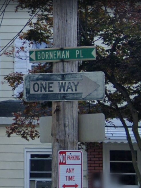 A stretch of Mamaroneck Avenue near the Hudson Grille was given the ceremonial name Paul Dillane Way after the late co-owner of that restauant. I don't know if this will stick around. 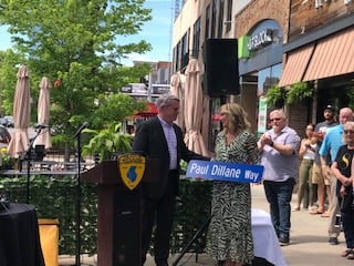 Just noticed today (May 21) on E. J. Conroy Drive (and it sets a record for length):U.S. Jewish War Veterans/U.S. Jewish War Veterans Ladies Auxiliary Drive. According to the Traffic Department, it is up only temporarily. 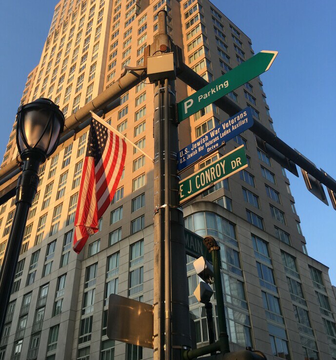 Picture courtesy of Aaron Woodin. White Plains has at present 488 named streets, with the nomenclature as follows:
140 Avenues 71 Roads 66 Streets 65 Places 42 Drives 37 Lanes 16 Courts 16 Circles 9 Ways 8 Terraces 5 Parkways 2 Closes 1 Boulevard 1 Crescent 1 Crossing 1 Esplanade 1 Expressway 1 Old Road 1 Run 1 Square 1 Trail and 2 with no road type (Ridgeway, Broadway) There are a large number of streets that were built after 1911 (the years for which complete minutes are available) that are public streets according to the city's Street Index. Yet they have never been accepted by the Common Council, which is a necessary step in making a privately developed road public. Such an oversight, if indeed that's what is going on, would not be unprecedented. See my entry on William Street.
I have contacted the Commissioner of Public Works about this, and in typical fashion I have not received a reply. These streets are: Davis Avenue south of Hartsdale Avenue Sterling Avenue NW of Post Road Longview Avenue south of Prescott Avenue Stratford Avenue from Ralph Avenue to Overlook Road Bolton Avenue near Ralph Avenue Bryant Avenue from Mamaroneck Avenue to Colonial Road Ogden Avenue sout of Locust Avenue Ralph Avenue south of Prescott Avenue Viewmont Place Robinhood Road west of North Street Kirby Terrace (original section) Park Terrace Collyer Place Gedney Terrace Soundview Terrace Locust Avenue Marlette Place Thomas Place Overlook Road Pleasant Avenue Mitchie Drive Earlwoode Drive Midchester Avenue Westview Avenue Church Court Parkview Court (pre-1936 section) Reynal Road (original portion) Amy Place Gene Place Meda Place Hewitt Avenue Brentwood Avenue Helena Avenue Thelma Place Wilmont Avenue Coralyn Avenue Hazleton Drive Norma Place Seeger Drive Blackthorn Lane Cushman Road Benedict Avenue McBride Avenue Cummings Avenue Fay Place Hilton Avenue Bird Place Lark Place Partridge Road Jennings Road Woodbrook Road (original section) Kass Road Laurel Road Mansfield Road Topland Road Idlewood Road Leith Place Ritchey Place Saxon Wood Park Drive Abbey Drive Birch Street Crestview Avenue Sunset Drive (except between Crestview and Hilldale) Highview Place Hilldale Avenue Woodale Place Northview Place Dale Street Manor Place Manor Avenue Belmont Street (original section) Rose Street (original section) Carrigan Avenue Hubbard Drive Morgan Place (original section) Craven Lane County Center Road Brockway Place Windward Avenue Wardman Street Antony Road Scott Circle Northdale Road (new section) Middale Road (new section) Southdale Road Leir Court Gabriel Court Birchwood Road Maplemoor Lane (new section) ??? Homeside Lane Willows Lane Copper Beach Circle Rosewood Road extension Roger Road Stanley Road Willow Brook Road Rolling Field Road Carriage Way (original section) Roland Drive (original section) Old Farm Circle Lana Circle Barton Road from Sammis Lane to Lambert Road Darby Court Monroe Drive Briga Lane Nina Lane Ellis Drive Greene Lane McGuiness Lane Walnut Court St. Mary's Place Renaissance Square Horton's Mill Road Certain streets in White Plains have been given ceremonial names (mainly shown on blue street name signs) to honor individuals. They are as follows:
Jerome “Bump” Robinson Blvd.- Ferris Avenue from Cemetery Rd. to Hamilton Ave. Jerome Robinson was founder of a drum corps at the Slater Center. Arts Avenue- Mamaroneck Avenue from Main St. to Martine Ave. The ArtsWestchester organization is located on the corner of Mamaroneck and Martine Gilda Radner Way- Chester Avenue The cancer support organization Gilda's Club, named for Gilda Radner, is located on Maple Avenue near Chester Antonio Meucci Place- Summit Avenue Antonio Meucci was a telephone inventor- the local Sons of Italy lodge is named for him Rev. Dr. Louis H. Wade Way- Fisher Court Reverend Wade was pastor at Bethel Baptist Church from 1966 to 1991 Det. Michael Perry Way- Court Street from Main St. to Martine Avenue and Tarrytown Road south of Central Avenue (green sign) Perry was a White Plains policeman who suffered a fatal heart attack while apprehending a suspect at the corner of Court and Main in 2010 Isabel Elsa Villar Blvd.- So. Lexington Avenue from Charlotte St. to Prospect St. Isabel Villar was executive director of El Centro Hispano in White Plains on South Lexington Rev. Dr. Lester Cousin Way- Orawaupum Street from Denison St. to W. Post Rd. Lester Cousin was pastor of Calvary Baptist Church on Orawaupum in White Plains from 1973 to 2011 Billy Delanoy Way- Mamaroneck Avenue from Carhart Ave. to Maple Ave. Billy Delanoy was a member of the White Plains Fire Department from 1978 until his death in 2013 A driveway separating two stores on the east side of Mamaroneck Avenue between Post Road and Mitchell Place, it was declared a public road by the Common Council in January 1966. It took until December 1968 for the council to wake up and realize it wasn't a street at all.
The following street names appear only on the official city map; they are paper streets which haven't been built. It's possible they will be one day.
WRIGHT STREET, BROOK PLACE, HILLTOP DRIVE, GENE CROSSING, NAT CROSSING, FOREST DRIVE, HAMPSHIRE COURT, PALMER AVENUE, PARK WAY, SOUTH WAY, LEEWARD AVENUE, BERNARD PLACE, FRANCIS PLACE, BARBARA LANE, FLORENCE PLACE, PARKVIEW AVENUE, PARKWAY EAST, EASTSHORE DRIVE Other streets have a paper component, meaning part of the planned street hasn't been built: Beech Street Greenacres Way Abbey Drive Crestview Drive Sunset Drive Hilldale Avenue St. Mary's Place The newest street in White Plains, not officially finished as of September 2017, this street which goes east from North Street was named for German conductor and humanitarian Kurt Masur (1927-2015) and his wife. Their son went to the German International School, which was the developer of this road.
Another relatively new street off North Street, where most of the recent development has been. It is south of Maplemoor Lane. The reason for the name is unknown.
This dead end road off Rosedale Avenue was started circa 2007, although, likely due to the collapse of the real estate market, no lots were sold until 2012. It was deeded to the city in 2013. I don't know who Nikki was.
Perhaps the worst street name in White Plains, this is another road named for a real estate development.
In 2007, this road connecting Court Street and Cottage Place was built alongside two high-rise apartment buildings, part of a project of the same name. It is not a square, or even a rectangle, due to a curve in the middle. Built circa 2006, it is a cul-de-sac off Old Mamaroneck Rd. between Bryant and Stratford Aves. It does have a stone gate, although if that or the name came first is unknown. The road was deeded to the city in 2008.
Planned in 1925 but not built until 2006, it is a short dead-end street off Crestview Drive with just one house on it. It was named for the nearby lake which was once known as St. Mary's Lake (now Silver Lake).
In conjunction with the construction of a retail and residential development called City Center, E.J. Conroy Drive between Main Street and Martine Avenue was closed and the City Center built over it. The remaining portion of the road, basically two driveways, was renamed City Place in 2003. This is similar to Westchester Mall Place but City Place does at least have addresses on it.
These roads are part of a golf-themed development near the Maplemoor Golf Course called The Fairways. They were built circa 1998 and were deeded to the city in 2003. The development is an offshoot of another subdivision called The Greens at White Plains, although those streets are not golf-named.
The Westchester, a mall, opened along Westchester Avenue and Bloomingdale Road in 1995. New York State law prohibits putting business names on highway signs, but apparently our Common Council considers it acceptable to violate the spirit of a law as long as one sticks to the letter of it. Thus, in 1997 the Common Council, wishing to accommodate the mall owner, declared a driveway to the mall's parking garage to be a street, whose name now appears on highway signs, to our fair city's everlasting shame.
The first enclosed shopping mall in White Plains was the appropriately-named White Plains Mall, which opened in October 1973 and is now facing demolition. It was followed by the Galleria which was completed in August 1980. Following that was the already-removed Westchester Pavilion on South Broadway and Maple Avenue, and then the Westchester. These roads make up a development called The Greens at White Plains, near the Maplemoor Golf Course. They were laid out circa 1996 on land once occupied by the Maginess family, although why the spelling was changed for the road is unknown. Nancy Maginess became the wife of Henry Kissinger. Walnut Court seems to be named for the tree. The reason for the name of Greene Lane is unknown, except that it sort of goes with the development name.
A dead-end street running north by northwest off Paddock Road, it is named for its proximity to Hillair Circle. It was finished circa 1993-4 and was deeded to the city in 2001.
When the Hillair Circle neighborhood was redeveloped in the mid-199th decade, the western part of Hunting Ridge Road was cut off from the eastern part and was renamed. The reason the new name was chosen is unknown. It was deeded to the city in 2001.
This street has a quirky history. Although it was shown on the developer's plans in 1931 as a road going from the northern to the southern side of Hillair Circle, it hadn't yet been started when it was the subject of a law suit in 1962, when the city wanted to accept the dedication of the road as public. The court ruled the fact that it was on an approved map meant it could be accepted at any time. However, it seemingly wasn't actually accepted until 1966. Various parts of the paper road were discontinued between 1984 and 2014, while the current portion, which goes north-northwest from Paddock Rd. past Rolling Ridge Rd., got houses in 1995, and the bed of the road was deeded to the city in 2001. Its name comes from its location in the middle of Hillair Circle.
Originally known as Mark Lane when built circa 1990 by Dr. Stanley and Audrey Markovits, it was renamed in 1991. The reason for the new name is unknown. It is a dead-end road off North Street, opposite the Westchester Hills golf course.
A dead-end road that goes northeast off North Street south of Haviland Manor, it was built circa 1989. The reason for the name is unknown.
A private, dead-end road that is west of North Street, it was built circa 1988. The reason for the name is unknown, but seems to be one of those made up of two geographic terms.
|
AuthorMy name is Cliff Blau. I was born and raised in White Plains, NY, and in 2015 became interested in learning more about the history of this fair city. The pathway I took into White Plains history was to discover the reason for the names of each of the streets. See https://www.google.com/maps/d/viewer?mid=1WvlOinVQnWh4KGDmEN7YPFfg4II for an annotated map of White Plains. Archives
March 2024
Categories |
 RSS Feed
